North Devon Catchment flood management plan - United Kingdom
Environment Agency
CFMP Catchment Flood Management Plan
CFMPs helps to understand the scale and extent of flooding now and in the future
and set policies for managing flood risk within the catchment.
CFMPs aim to promote more sustainable approaches to managing flood risk. The policies identified in
the CFMP will be delivered through a combination of different approaches. Together with our partners,
we will implement these approaches through a range of delivery plans, projects and actions.
Through the CFMPs, is possible to assess inland flood risk across all of England and Wales for the first time.
The CFMP considers all types of inland flooding, from rivers, ground water, surface water and tidal
flooding, but not flooding directly from the sea (coastal flooding), which is covered by
Shoreline Management Plans (SMPs).
The role of CFMPs is to establish flood risk management policies which delivers sustainable
flood risk management for the long term. This is essential if we are to make the right investment
decisions for the future and to help prepare ourselves effectively for the impact of climate change.
The purpose of a CFMP in managing flood risk
CFMPs will be used to help targeting limited resources where the risks are greatest.
This CFMP identifies flood risk management policies to assist all key decision makers in the catchment.
It was produced through a wide consultation and appraisal process; however it is only the first step
towards an integrated approach to Flood Risk Management.
CFMPs should be used to inform planning and decision making by key stakeholders such as:
- the Environment Agency, who will use the plan to guide decisions on investment in further plans, projects or actions.
- Regional Assemblies and local authorities who can use the plan to inform spatial planning activities and emergency planning.
- Internal Drainage Boards (IDB), water companies and other utilities to help plan their activities in the wider context of the catchment; transportation planners.
- landowners, farmers and land managers that manage and operate land for agriculture, conservation and amenity purposes.
- the public and businesses to enhance their understanding of flood risk and how it will be managed.
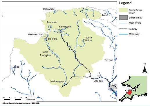
North Devon Catchment overview
The North Devon CFMP is one of 77 CFMPs for England and Wales.
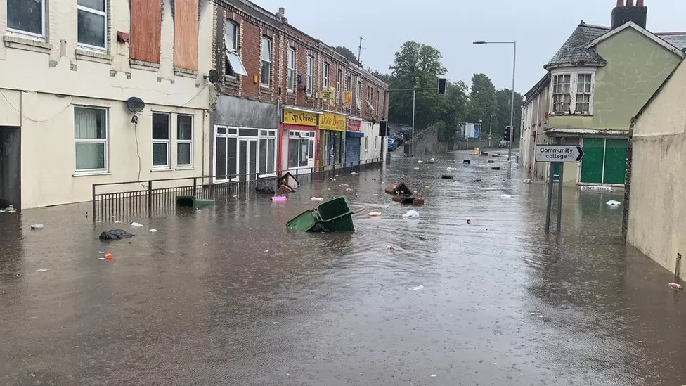
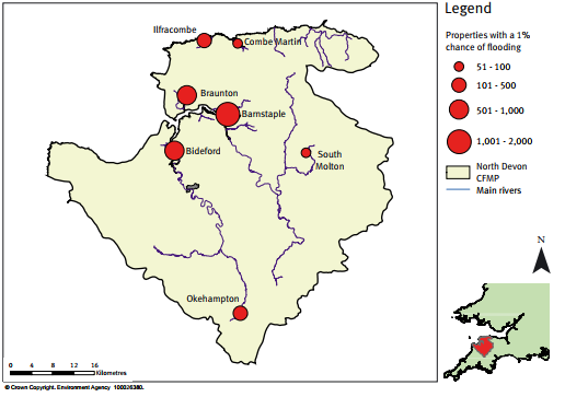
Flood risk in North Devon is mainly from rivers and surface water, although there is also significant
flood risk from tidal flooding in Barnstaple, Bideford and Ilfracombe. In addition to these
communities there is also risk to people, property and infrastructure concentrated around Braunton,
Combe Martin and Okehampton. Several significant floods have occurred in North Devon, including the
Lynmouth flood in 1952. During the autumn 2000 floods severe flood warnings were issued for the lower
reaches of the rivers Taw, Torridge and East Lyn.
The North Devon catchment includes the areas drained by the River Taw and its tributaries, the
River Torridge and its tributaries, and the North Devon Coastal Rivers that flow directly into the sea.
The North Devon CFMP covers an area of some 2,300 square kilometres (900 square miles).
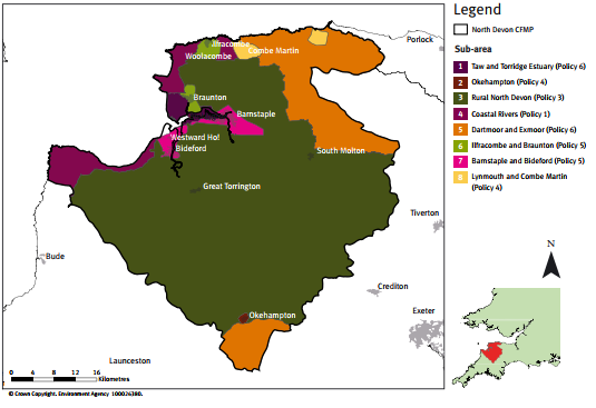
North Devon is a catchment with varied landscape, including the rare Culm grasslands, marshland,
parts of the two National Parks of Exmoor and Dartmoor, and woodlands. Much of the countryside is
recognised for its environmental and cultural value including an Area of Outstanding Natural Beauty
(AONB) and 500 Scheduled Monuments. There are many other ecologically, socially and historically
important sites in the catchment and a network of good quality river courses, with six Special Areas of
Conservation (SAC) and 62 Sites of Special Scientific Interest (SSSI).
The main urban areas are Barnstaple, Bideford, Braunton, Combe Martin, Great Torrington, Ilfracombe,
Lynton and Lynmouth, North Tawton, Okehampton and South Molton. These densely populated towns are
surrounded by a mostly rural catchment with properties scattered over the area.
Steeply sloping tributaries drain from the high ground of Exmoor and Dartmoor to the low-lying Taw
and Torridge estuary, or, for the small coastal catchments, directly to the sea. Annual rainfall
ranges from more than 2,300mm (90in) in the upland areas of Dartmoor and Exmoor to 800mm (31in) at
the coast. The England and Wales average is 920mm (36in).
MDSF - Modelling and Decision Support Framework
The MDSF is the Modelling and Decision Support Framework developed by HR Wallingford,
Halcrow, CEH Wallingford and FHRC for DEFRA and the Environment Agency. MDSF is a tool to be used by
Environment Agency and consultant staff in the development of CFMPs (Catchment Flood Management Plans),
SMPs and other flood studies.
MDSF consists of a set of Procedures and a GIS based Software front end. The MDSF website provides a
forum for distribution of information, documentation, upgrades and user support for the MDSF software
and the procedures.
The modelling and decision support framework is inspired by ideas from the Eurotas project7 and from
the experience of the first author and others on flood management plans in Hungary, Argentina and
elsewhere using geo-graphical information systems (GIS) and catchment modelling.
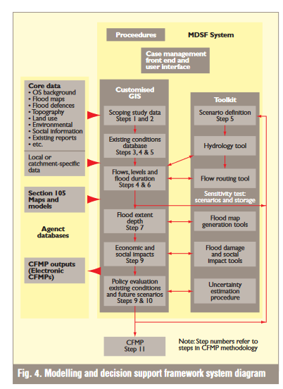
A system diagram of the modelling and decision support framework is shown in
Fig. 4.
The core data for each catchment is loaded into a customised geographic data management and analysis
system.
Metadata (which is data that describes the contents, format and origin of each data file) is used to
ensure long-term data integrity and compliance with Environment Agency standards and to facilitate
the return to the Environment Agency of ‘electronic catchment flood management plans’ which can be
accessed by Environment Agency staff. The GIS is provided with a user interface
which enables users to run and keep track of ‘what-if’ cases consisting of different combinations of
climate, land use change and flood management policies, and present the results in easily assimilable
graphical and tabular formats.
A modelling toolkit to implement the catchment flood management plan guidelines and to run the
required cases is provided.
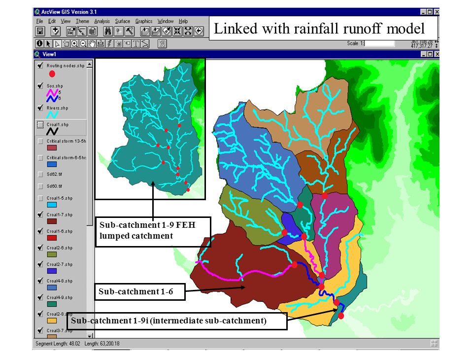
- hydrology is external to the modelling and decision support framework and is carried out by a modified version of the Flood Estimation Handbook rainfall–runoff method which contains estimates of the effects of climate change, urbanisation and land management, based on current knowledge.
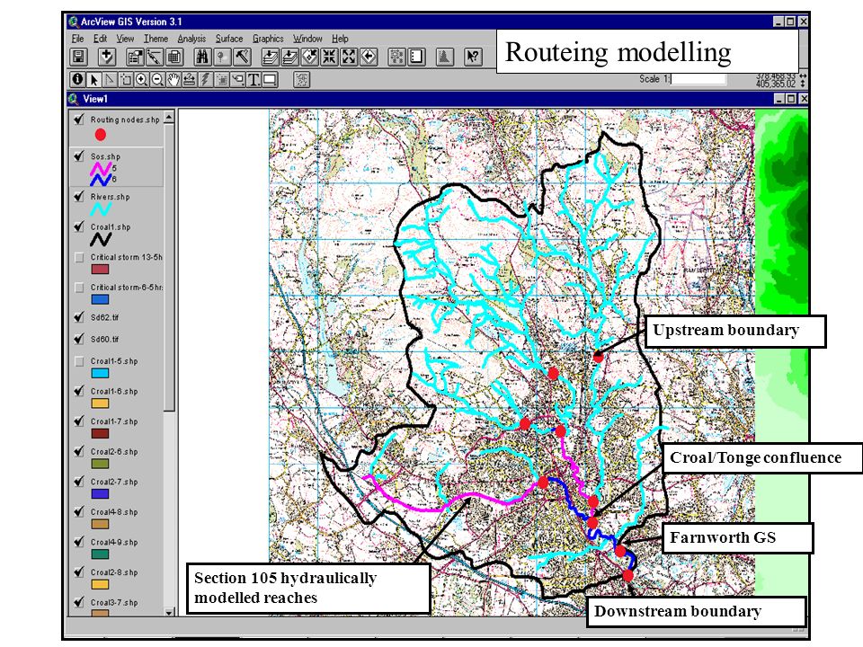
- The hydraulic modelling is also external to the GIS but with convenient links for the importation of flood levels and hydrographs.
- The system includes a raster-based GIS tool for fast, automatic and objective plotting of flood outlines and depths using water levels from the hydraulic model and a digital elevation model.
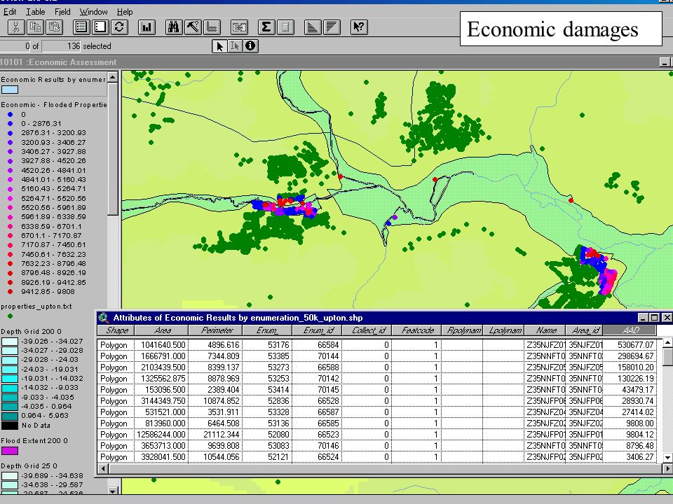
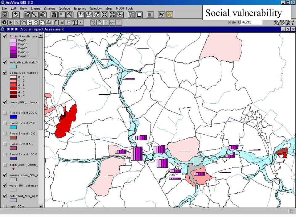
- The socio-economic impact module uses the latest available census and other data, and depth-damage curves built into the GIS to calculate impacts automatically. In conventional economic terms, it will give a good high-level picture, which can subsequently be improved at strategy or project level by using more accurate level data and more detailed damage estimates. It will make available a much richer set of impacts than current methods, including social impacts on populations and vulnerable groups at risk.
- Lastly, the system includes a module to assist users and decision makers in appreciating the levels of uncertainty in their data, risk scenarios and flood management policies, and will export tabular results for use in policy evaluation. As a strategy of the broad-scale modelling programme, the intellectual property rights of the software will be retained by the Environment Agency and open code will be supplied to researchers to encourage further research.
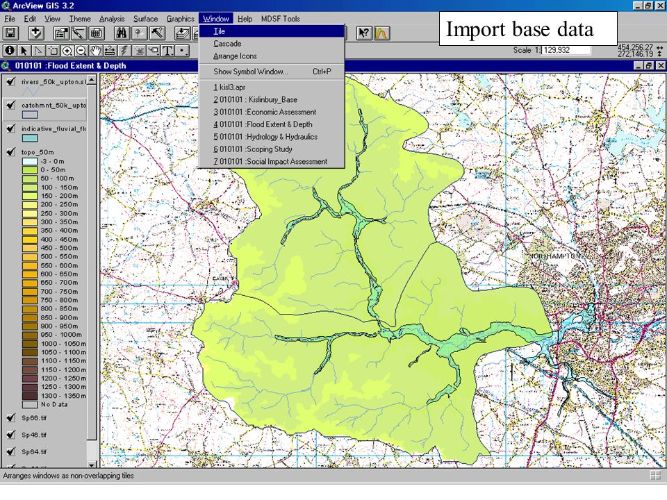
A customised GIS
The ‘what-if’ front-end stores a database of cases and acts as a central hub to guide the use of
the customised ArcView GIS, which stores and process- es the data.
The first step is to investigate the core data that has been assembled for the catchment flood
management plan. These datasets are imported and visualised in the GIS, assisting in the rapid
exploration and understanding of the catchment. For ease of handling, the core datasets are
grouped into a number of ‘views’ within the GIS, each appropriate to a different stage of the
catchment flood management plan process, as follows:
- scoping study
- flows and levels
- flood extent and depth
- economic damages
- social impact assessment
- environmental impact